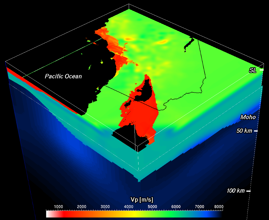
Summary
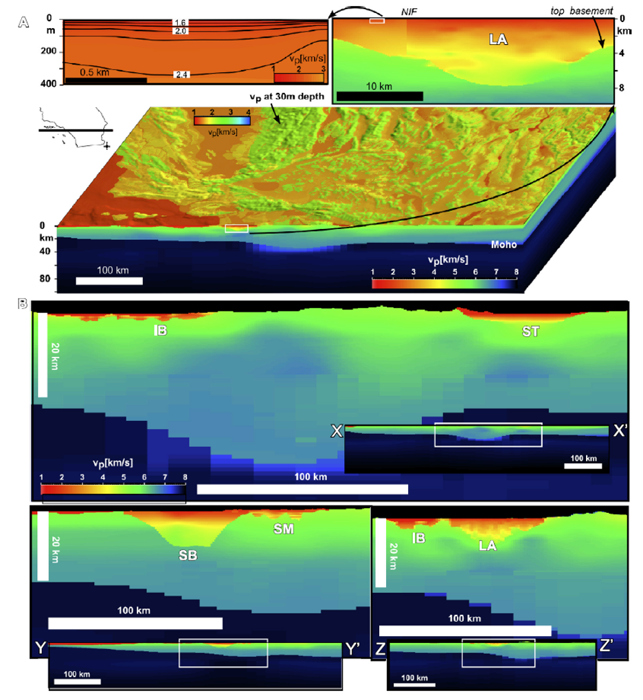
CVM-H v15.1 is comprised of detailed basin velocity descriptions based on tens of thousands of direct velocity (Vp, Vs) measurements and incorporates the locations and displacement of major fault zones that influence basin structure.
Quicklinks
Description
| Name | CVM_H_v15_1 |
| Title | Community Velocity Model – Harvard (CVM-H), a 3D structural velocity model for the southern California crust and upper mantle. |
| Type | 3-D Tomography Earth Model |
| Sub Type | Compressional and Shear-wave velocity (km/s) and density (kg/m3) model |
| Year | 2015 |
| Short Description | CVM-H v15.1 is comprised of detailed basin velocity descriptions based on tens of thousands of direct velocity (Vp, Vs) measurements and incorporates the locations and displacement of major fault zones that influence basin structure. These basin descriptions were used to developed tomographic models of crust and upper mantle velocity and density structure, which were subsequently iterated and improved using 3D waveform adjoint tomography. |
| Authors: | |
| Andreas Plesch | |
| Department of Earth and Planetary Sciences | |
| Harvard University | |
| Cambridge, MA 02138, USA | |
| John H. Shaw | |
| Department of Earth and Planetary Sciences | |
| Harvard University | |
| Cambridge, MA 02138, USA | |
| Carl Tape | |
| Geophysical Institute and Department of Geosciences | |
| University of Alaska Fairbanks | |
| Fairbanks, AK 99775-7320, USA | |
| Previous Model | CVM_H_v11_9_1 |
| Reference Model | None |
| Model Download | SCEC-CVM-H-v15-1-n4.nc (see metadata), is the netCDF-4 Classic file for the model as a function of depth |
| Model Homepage | https://www.scec.org/research/cxm |
| Depth Coverage | 4km to -50km (below sea level) |
| Area | Southern California (latitude 30.95°N/36.613°N, longitude 113.333°W/120.862°W) |
| Data Set Description | The SCEC CVM-H v15.1 model is a 3-D description of crust and upper mantle velocity structure in southern California implemented as a Unified Structural Representation (USR). The USR is comprised of detailed basin velocity descriptions that are based on tens of thousands of direct velocity (Vp, Vs) measurements and incorporate the locations and displacement of major fault zones that influence basin structure. These basin descriptions were used to developed tomographic models of crust and upper mantle velocity and density structure, which were subsequently iterated and improved using 3D waveform adjoint tomography. The resulting model provides a detailed description of the structure of the southern California crust and upper mantle that reflects the complex tectonic history of the region. The crust thickens eastward as Moho depth varies from 10 to 40 km reflecting the transition from oceanic to continental crust. Deep sedimentary basins and underlying areas of thin crust reflect Neogene extensional tectonics overprinted by transpressional deformation and rapid sediment deposition since the late Pliocene. CVM-H v15.1 model consists of basin structures defined using high-quality industry seismic reflection profiles and tens of thousands of direct velocity measurements from boreholes (Süss and Shaw, 2003). The basin structures are also compatible with the locations and displacements of major faults represented in the SCEC Community Fault Model (CFM) (Plesch et al., 2007). These basin structures were used to develop travel time tomographic models of the crust (after Hauksson, 2000) extending to a depth of 35 km, and upper mantle teleseismic and surface wave models extending to a depth of 300 km (Prindle and Tanimoto, 2006). These various model components were integrated and used to perform a series of 3D adjoint tomographic inversions that highlight areas of the model that were responsible for mismatches between observed and synthetic waveforms (Tape et al, 2009). Sixteen tomographic iterations, requiring 6800 wavefield simulations, yielded perturbations to the starting model that have been incorporated in the latest model release. CVM-H v15.1 includes a Moho surface, opening up the offshore Santa Maria basin to the western model margin, a detailed representation of the San Bernardino basin, a much smoother transition between low resolution area and high resolution area at its southern border in the Los Angeles region and removal of various small near surface artifacts. This Moho surface was compiled by Tape et al. from a large number of data sources, including global data sets, receiver functions and local studies. In replacing this surface care was taken that the depth interval around the Moho level both in the mantle and in the crustal portions of the model which were affected by this change, were assigned the correct domain, and consequently assigned velocities extrapolated from the underlying mantle model or from the crustal background model. In the offshore Santa Maria basin we extended the definition of the basement surface using reflection seismic data to the very western margin of the model and to the north in order to remove an abrupt transition from the basin to background. We smoothly extrapolated sediment velocities from the onshore model into this new basinal area. Another basin, the relatively small San Bernardino basin, is now represented in the model. The basement surface is based on gravity data (Anderson, 2004) and seismic reflection data (Stephenson et al., 2004). To the west the basin is connected by a thin veneer of sediments to the Los Angeles basin whereas to the ESE the basin is represented as tapering out as is the case in other such basin representation. The ESE is the deepest part of the basin, and the data do not preclude a continuation of the basin in this direction. The Vp velocity structure in the basin is defined by stacking velocities (Stephenson et al., 2002) and a 1D velocity profile (Graves, 2004). Vs is derived from Vp using Brocher (2004). The NetCDF version of CVM-H was produced using SCEC UCVM v19.4. The horizontal dimensions of the model were defined to match the dimension of the CVM-H low resolution region. The vertical dimensions of this NetCDF model were defined as 4km to -50km. Points above ground were populated with a “missing data” value = -99999.0. Points in water above ground are defined with Vp = 1480.0 and Vs = 0 and density = 1000.0 |


Citations and DOIs
To cite the original work behind this Earth model:
- Shaw, J. H., Plesch, A., Tape, C., Suess, M., Jordan, T. H., Ely, G., Hauksson, E., Tromp, J., Tanimoto, T., Graves, R., Olsen, K., Nicholson, C., Maechling, P. J., Rivero, C., Lovely, P., Brankman, C. M., & Munster, J. (2015). Unified Structural Representation of the southern California crust and upper mantle. Earth and Planetary Science Letters, 415, 1-15. https://doi.org/10.1016/j.epsl.2015.01.016.
To cite IRIS DMC Data Products effort:
- Trabant, C., A. R. Hutko, M. Bahavar, R. Karstens, T. Ahern, and R. Aster (2012), Data Products at the IRIS DMC: Stepping Stones for Research and Other Applications, Seismological Research Letters, 83(5), 846–854, https://doi.org/10.1785/0220120032.
DOI for this EMC webpage: https://doi.org/10.17611/dp/emc.2020.cvmharvv15.1
References
- Anderson, M., Matti, J., Jachens, R., 2004. Structural model of the San Bernardino basin, California, from analysis of gravity, aeromagnetic, and seismicity data. J. Geophys. Res. 109, B04404. https://doi.org/10.1029/2003JB002544
- Hauksson, E., 2000. Crustal structure and seismicity distributions adjacent to the Pacific and north America plate boundary in southern California. J. Geophys. Res. 105, 13,875–13,903.
- Plesch, A., Shaw, J.H., Benson, C., Bryant, W.A., Carena, S., Cooke, M., Dolan, J.F., Fuis,G., Gath, E., Grant, L., Hauksson, E., Jordan, T.H., Kamerling, M., Legg, M., Lindvall, S., Magistrale, H., Nicholson, C., Niemi, N., Oskin, M.E., Perry, S., Planansky, G., Rockwell, T., Shearer, P., Sorlien, C., Suess, M.P., Suppe, J., Treiman, J., Yeats, R., 2007. Community Fault Model (CFM) for Southern California. Bull. Seismol. Soc. Am. 97 (6), 1793–1802.
- Prindle, K., Tanimoto, T., 2006. Teleseismic surface wave study for S-wave velocity structure under an array: Southern California. Geophys. J. Int. 166, 601–621. https://doi.org/10.1111/j.1365-246X.2006.02947.
- Shaw, J.H., Suppe, J., 1996. Earthquake hazards of active blind-thrust faults under the central Los Angeles basin, California. J. Geophys. Res. 101 (B4), 8623–8642.
- Shaw, J.H., Plesch, A., 2012. 3D structural velocity model of the Santa Maria Basin, CA, for improved strong ground motion prediction, National Earthquake Hazards Reduction Program (NEHRP). Final Technical Report, Grant G12AP20020.
- Small, P., Gill, D., Maechling, P. J., Taborda, R., Callaghan, S., Jordan, T. H., Ely, G. P., Olsen, K. B., & Goulet, C. A. (2017). The SCEC Unified Community Velocity Model Software Framework. Seismological Research Letters, 88(5). doi: https://doi.org/10.1785/0220170082
- Stephenson, W.J., Odum, J.K., Williams, R.A., Anderson, M.L., 2002. Delineation of faulting and basin geometry along a seismic reflection transect in urbanized San Bernardino Valley, California. Bull. Seismol. Soc. Am. 92 (6), 2504–2520.
- Suess, P., Shaw, J.H., 2003. P wave seismic velocity structure derived from sonic logs and industry reflection data in the Los Angeles basin, California. J. Geophys. Res. 108 (B3). https://doi.org/10.1029/2001JB001628.
- Tape, C., Liu, Q., Maggi, A., Tromp, J., 2009. Adjoint tomography of the southern California crust. Science 325, 988–992.
- Tape, C., Liu, Q., Maggi, A., Tromp, J., 2010. Seismic tomography of the southern California crust based on spectral-element and adjoint methods. Geophys. J. Int. 180, 433–462.
- Tape, C., Plesch, A., Shaw, J.H., Gilbert, H., 2012. Estimating a continuous Moho surface for the California Unified Velocity Model. Seismol. Res. Lett. 83 (4), 728–735.
Credits
Model provided by Philip Maechling
Timeline
- 2020-08-28
- online


